Lens, Belgium
Appearance
Lens
Linse (Picard) | |
|---|---|
 | |
| Coordinates: 50°33′N 03°54′E / 50.550°N 3.900°E | |
| Community | French community |
| Region | Wallonia |
| Province | Hainaut |
| Arrondissement | Mons |
| Government | |
| • Mayor | Isabelle Galant (MR) (MDC) |
| • Governing party/ies | MDC (Mouvement Démocratique Communal) |
| Area | |
| • Total | 49.83 km2 (19.24 sq mi) |
| Population (2018-01-01)[1] | |
| • Total | 4,508 |
| • Density | 90/km2 (230/sq mi) |
| Postal codes | 7870 |
| NIS code | 53046 |
| Area codes | 065 |
| Website | www.lens.be |
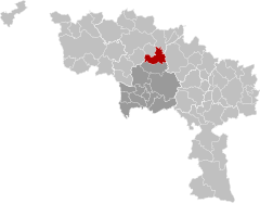
Lens (French pronunciation: [lɑ̃s] ; Picard: Linse) is a municipality of Wallonia located in the province of Hainaut, Belgium.
In 2007 its population was 4042.[2] The total area is 49.42 km² which gives a population density of 80 inhabitants per km².
The municipality consists of the following districts: Bauffe, Cambron-Saint-Vincent, Lens, Lombise, and Montignies-lez-Lens.
It is located along the N56 road.[3]
References
[edit]- ^ "Wettelijke Bevolking per gemeente op 1 januari 2018". Statbel. Retrieved 9 March 2019.
- ^ "Werkelijke bevolking per gemeente op 1 januari 2007 / Population de droit par commune au 1 janvier 2007 (.xls)". Archived from the original on 2008-11-23. Retrieved 2011-06-27.
- ^ "Geografische coördinaten van de gemeenten (.xls)". Archived from the original on 2008-11-24. Retrieved 2011-06-27.
External links
[edit] Media related to Lens, Belgium at Wikimedia Commons


